
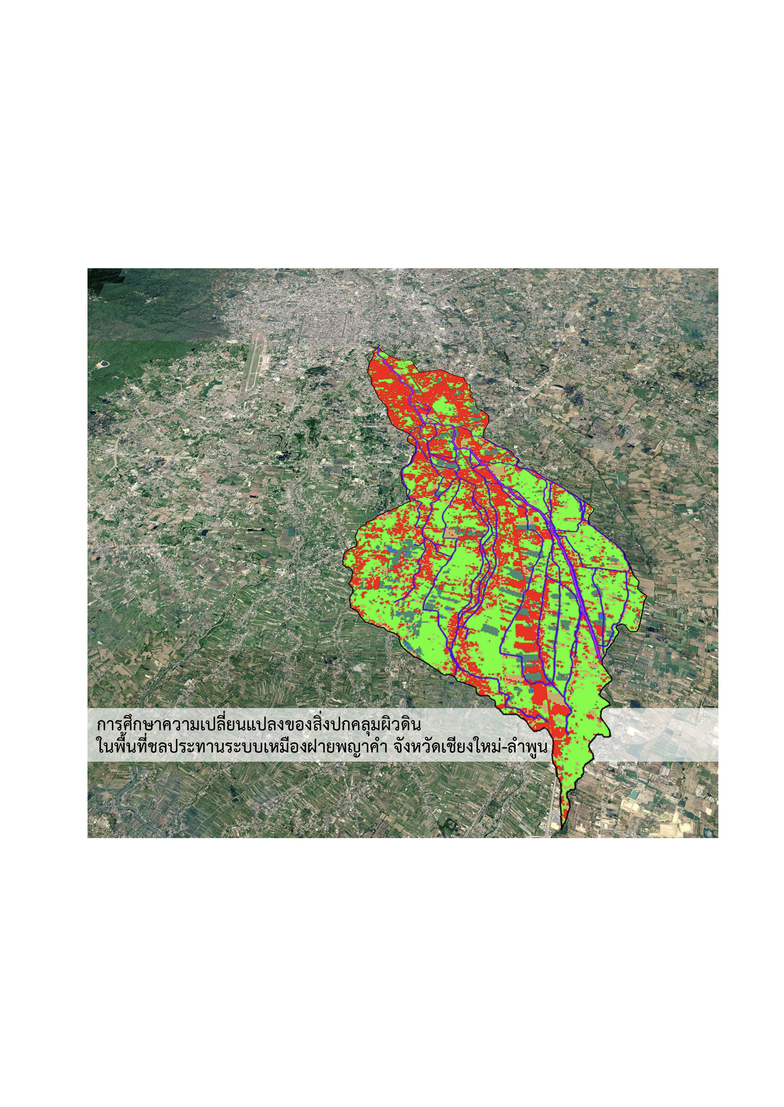
A Study of Land Cover Changes in the Phaya Kham irrigation area, Chiang Mai and Lamphun provinces
Article Sidebar
Main Article Content
Abstract
This study investigates land cover change within the irrigated area of the Phaya Kham Muang Fai system in Chiang Mai Province, Thailand, between 1996 and 2026. The objective is to examine landscape dynamics and their implications for ecological structure in the context of urban expansion. A supervised land cover classification approach was applied using Geographic Information Systems (GIS), based on satellite imagery from two time periods. A land use change matrix was constructed to assess both persistent areas and transitional land cover changes.
The results indicate a significant decline in wetland areas, with 8,399.51 rai converted to agricultural land and 3,928.13 rai transformed into urban and built-up areas. Additionally, 6,506.90 rai of agricultural land were converted to urban use. Although the net agricultural area appears relatively stable, only 39% of the original agricultural land remained unchanged over the 30-year period, reflecting a structural turnover exceeding 60%.
These findings reveal a transition from a permeable landscape with high water retention capacity to an increasingly impervious urban landscape. Such changes have significant implications for hydrological regulation, ecological resilience, and the functional role of the Muang Fai irrigation system as blue-green infrastructure within the urban environment. The study highlights the need for integrated land and water management policies that incorporate ecological and landscape perspectives alongside conventional engineering-based flood control measures to enhance long-term urban resilience.
Article Details

This work is licensed under a Creative Commons Attribution-NonCommercial-NoDerivatives 4.0 International License.
References
Anderson, J. R., Hardy, E. E., Roach, J. T., & Witmer, R. E. (1976). A land use and land cover classification system for use with remote sensor data [Government report]. U.S. Geological Survey. https://doi.org/10.3133/pp964
Campbell, J. B., & Wynne, R. H. (2011). Introduction to remote sensing (5th ed.). Guilford Publications. https://books.google.co.th/books?id=NkLmDjSS8TsC
Chummathaya, A., & Ongsawangchai, N. (2018). Urbanization and urban context variants of old districts in Chiang Mai. JEDI : Journal of Environmental Design Innovation, 5(1), 60–81. https://so02.tci-thaijo.org/index.php/jed/article/view/136827
Congalton, R. G., & Green, K. (2019). Assessing the accuracy of remotely sensed data: Principles and practices (3rd ed.). CRC Press.
Folke, C. (2006). Resilience: The emergence of a perspective for social–ecological systems analyses. Global Environmental Change, 16(3), 253–267. https://doi.org/10.1016/j.gloenvcha.2006.04.002
Geo-Informatics Center for Thailand (GISTHAI). (1999). Geographic information system. http://www.gisthai.org/v2/index.php/resources/education/menu-learning-gis
GIS Geography. (2021). Vector vs raster: What’s the difference between GIS spatial data types?. https://gisgeography.com/spatial-data-types-vector-raster/
Google Earth. (2021). Aerial photograph of Chiang Mai-Lamphoon Basin [Aerial imagery]. Google. https://earth.google.com
Gu, Z., Phakdimek, S., Nagami, K., & Komori, D. (2025). Relationship between urbanization–induced land use changes and flood risk: Case study in Chiang Mai, Thailand. Water, 17(3). https://doi.org/10.3390/w17030327
Hersperger, A. M., Grădinaru, S. R., Pierri Daunt, A. B., Imhof, C. S., & Fan, P. (2021). Landscape ecological concepts in planning: Review of recent developments. Landscape Ecology, 36(8), 2329–2345. https://doi.org/10.1007/s10980-021-01193-y
Humboldt State University. (2017). Raster to vector: Conversion between data models. http://gsp.humboldt.edu/olm_2017/Lessons/GIS/08%20Rasters/RasterToVector.html
Jensen, J. R. (2015). Introductory digital image processing: A remote sensing perspective. Pearson Education. https://books.google.co.th/books?id=BWx3CgAAQBAJ
Land Development Department. (2022). Manual for establishing targets and indicators for Land Degradation Neutrality (LDN) to determine land degradation management measures at the local level. https://www.ldd.go.th/web_unccd/File_PDF/ Manual_LDN2565.pdf
Landis, J. R., & Koch, G. G. (1977). The measurement of observer agreement for categorical data. Biometrics, 33(1), 159–174. https://doi.org/10.2307/2529310
Lek-Prapai Viriyahpant Foundation. (2016, January 31). Phaya Kham weir and canal. https://lek-prapai.org/home/view.php?id=428
Lertvicha, P., Methin, S., & Namthep, N. (2009). “Muang Fai” managed water, managed people on the basis of geography and culture. Than Panya.
Lillesand, T. M., Kiefer, R. W., & Chipman, J. W. (2015). Remote sensing and image interpretation (7th ed.). Wiley.
Maneesatit, P. (2016). Changes of Muang Phaya Kham System, Amohie Mueang, Changwat Chiang Mai [Master's thesis, Chulalongkorn University]. Chula ETD. https://digital. car.chula.ac.th/chulaetd/72210
Maneesatit, P. (2023). Study of land cover in “Lanna bioregion”: A case study of Suan Sak campus, Chiang Mai University. JEDI : Journal of Environmental Design Innovation, 10(2), 184–203. https://so02.tci-thaijo.org/index.php/jed/article/view/256211
Maneesatit, P., & Dankittikul, C. (2025). A future approach of Muang Fai irrigation systems in urban area of Chiang Mai province: A systematic review. Journal of Landscape Architecture and Planning, 7(1), 41–62. https://so01.tci-thaijo.org/index.php /LAJ/article/view/280733
Mitrearth [@mitrearth]. (2023, May 19). Chiang Mai Basin topography [Post]. Facebook. https://www.facebook.com/mitrearth/posts/755774196341386/
Mungsunti, A., & Parton, K. A. (2019). The sustainability of the muang fai irrigation system of northern Thailand. AIMS Environmental Science, 6(2), 77–93.
Olofsson, P., Foody, G. M., Herold, M., Stehman, S. V., Woodcock, C. E., & Wulder, M. A. (2014). Good practices for estimating area and assessing accuracy of land change. Remote Sensing of Environment, 148, 42–57. https://doi.org/10.1016/j.rse.2014.02.015
Rakpan, K. (2020). Living museum design for cultural tourism in Inthakhil Village, Inthakhil Subdistrict, Mae Taeng District, Chiang Mai Province. Chiang Mai Rajabhat University Thai Research Database. https://cmudc.library.cmu.ac.th/frontend/Info/ item/dc:183528
Royal Irrigation Department. (2008). Phaya Kham weir irrigation area [Government report]. Royal Irrigation Department.
Sittipong, Y., Shibata, S., & Imanishi, J. (2025). The influence of policies on changing landscape hydro-ecological infrastructure in an urban area: A case study of Chiang Mai City, Thailand. Landscape and Ecological Engineering, 21(4), 895–919. https://doi.org/10.1007/s11355-025-00682-5
Surarerks, W. (1985). Historical development and management of irrigation systems in Northern Thailand. Social Research Institute, Chulalongkorn University.
Tongdeelert, C. (2019, June 26). Muang Fai: A legacy of traditional water management wisdom from northern Thailand. The Citizen Plus Thai PBS. https://drive. google.com/file/d/1xjwiYChLhzGNhtiuyHE8CHlb4-rLFYEo/view?usp =sharing
Tongdeelert, C., & Lohmann, L. (1991). The muang fai irrigation system of northern Thailand. Ecologist, 21, 101–106. https://www.researchgate.net/publication/ 322804696_The_muang_faai_irrigation_system_of_northern_Thailand
United States Geological Survey (USGS). (2026). Satellite imagery of the study area. https://earthexplorer.usgs.gov/
Yodcharoen, S., Harintaka, S., Srisonphan, S., Nualchawee, K., & Silapathong, C. (2017). Land cover classification from satellite images in lam pachi basin by decision tree method. In Thai societies of agricultural engineering (Ed.), Proceeding, The 18th TSAE National Conference and the 10th International Conference : TSAE 2017 (pp. 192–197). Thai societies of agricultural engineering.
