
การศึกษาสิ่งปกคลุมผิวดินของ “ชีวภูมิภาคล้านนา”: กรณีศึกษาเขตการศึกษาสวนสัก มหาวิทยาลัยเชียงใหม่
Article Sidebar
Main Article Content
บทคัดย่อ
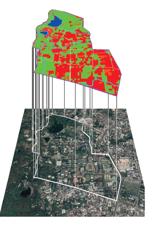
บทความนี้ มีวัตถุประสงค์เพื่อจำแนกสิ่งปกคลุมผิวดินจากภาพถ่ายดาวเทียม โดยใช้ระบบภูมิสารสนเทศภูมิศาสตร์ ด้วยวิธีการจำแนกสิ่งปกคลุมผิวดินแบบกำกับดูแล (supervised landcover classification) ในพื้นที่ศึกษาบริเวณเขตการศึกษาสวนสัก มหาวิทยาลัยเชียงใหม่ และเปรียบเทียบผลการศึกษากับข้อมูลจากการสำรวจพื้นที่ภายใต้โครงการสนับสนุนการจัดลำดับมหาวิทยาลัยเชียงใหม่ เพื่อจัดอันดับมหาวิทยาลัยสีเขียวโลก ปี 2019 ผลการศึกษา พบว่า การจำแนกสิ่งปกคลุมผิวดินแบบกำกับดูแล ในพื้นที่ศึกษา มีค่าความถูกต้องโดยรวม อยู่ที่ร้อยละ 83 มีค่าสัมประสิทธิ์แคปปาอยู่ที่ 0.74 โดยพบว่ามีค่าความถูกต้องของผู้ใช้ ในพื้นที่ที่เป็นน้ำสูงสุดที่ร้อยละ 100 และมีค่าต่ำสุด คือ ป่าและต้นไม้ใหญ่คิดเป็นร้อยละ 66.67 นอกจากนี้ เมื่อนำผลการจำแนกสิ่งปกคลุมผิวดินมาเปรียบเทียบกับข้อมูลจากการสำรวจพื้นที่ พบว่า มีความคลาดเคลื่อนของปริมาณสิ่งปกคลุมผิวดินค่อนข้างมาก เนื่องจากภาพถ่ายดาวเทียมที่นำมาวิเคราะห์มีความละเอียดของภาพที่ค่อนข้างน้อย จึงทำให้ไม่สามารถจำแนกสิ่งปกคลุมผิวดินในพื้นที่ที่มีขนาดเล็กได้ โดยเฉพาะสวนหย่อมขนาดเล็ก และเส้นทางน้ำขนาดเล็ก อย่างไรก็ตาม หากนำวิธีการจำแนกสิ่งปกคลุมผิวดินดังกล่าวมาประยุกต์ใช้ร่วมกับการสำรวจพื้นที่ นอกจากจะช่วยให้ข้อมูลมีความถูกต้องแม่นยำมากขึ้นแล้ว ยังเป็นการลดเวลาและค่าใช้จ่ายในการลงพื้นที่สำรวจได้อีกทางหนึ่ง
Article Details

อนุญาตภายใต้เงื่อนไข Creative Commons Attribution-NonCommercial-NoDerivatives 4.0 International License.
เอกสารอ้างอิง
Barnes, T.G. (2000). Landscape ecology and ecosystems management. Lexington KY: University of Kentucky.
Barrett, G.W., & Bohlen, P.J. (1991). Landscape ecology. In Hudson, W. (Ed.). Landscape linkage and biodiversity (pp. 149–161). Washington, D.C.: Island Press.
Chindapol, S. (2019). Khrongkarn sanapsanun karn chat lamdap mahawitthayalai Chiang Mai phuea chat andap mahawitthayalai sikhiao lok 2019. (In Thai) [Final sustainable report of chiang mai university for the UI green metric ranking 2019] Chiang Mai: Chiang Mai university.
Forman, R.T.T. & Wilson, E.O. (1995). Land mosaics. Cambridge: Cambridge University Press.
Geo-Informatics Center for Thailand (GISTHAI). (1999). Geographic information system. Retrieved November 7, 2019, from http://www.gisthai.org/v2/index.php/resources/education/menu-learning-gis
GIS Geography. (2021). Vector vs raster: what’s the difference between GIS spatial data types?. Retrieved November 7, 2019, from https://gisgeography.com/spatial-data-types-vector-raster/
GISTDA. (2015). Visual interpretation. Retrieved November 7, 2019, from https://www.gistda.or.th/ main/th/node/997
Humboldt State University. (2017). Raster to vector: conversion between data models. Retrieved November 9, 2019, from http://gsp.humboldt.edu/olm_2017/Lessons/GIS/08 Rasters/Raster ToVector.html
Landis, J.R.; & Koch, G.G. (1977). The measurement of observer agreement for categorical data. Biometrics, 33 (1), 159–174.
Lisle, R.J. (2004). Geological structures and maps a practical guide. Oxford: Elsevier.
Nikolli, P. (2010). Land cover classification in Albania. In Wagner W. & Székely, B. (Ed.). Proceeding, International Conference on Spatial Data Infrastructures 2010 (pp. 412-416). Vienna: Vienna university of technology.
Odum, E.P. (1971). Fundamentals of ecology. Philadelphia: W.B. Saunders co.
Rattana, C. (2019). Bot kwam wicha karn karn plae phap dao tiem duay computer. (In Thai) [Academic article: satellite image classification using computer]. Retrieved January, 10, 2020, from http://blog.bru.ac.th/wp-content/plugins/download-attachments/includes/download.php?id=10313
United States Geological Survey (USGS). (2020). Satellite imagery of the study area. Retrieved January, 10, 2020. from https://earthexplorer.usgs.gov/
Yodcharoen, S., et al. (2017). Karn chamnaek sing pokkhlum din chak phapthai daothiam nai phuenthi lumnam lam phachi duai withi decision tree. (In Thai) [Land cover classification from satellite images in lam pachi basin by decision tree method]. Proceeding, The 18th TSAE National Conference and the 10th International Conference: TSAE 2017 (pp. 192–197). Bangkok: Thai socities of agricultural engineering.
