
การศึกษาความเปลี่ยนแปลงของสิ่งปกคลุมผิวดินในพื้นที่ชลประทานระบบเหมืองฝายพญาคำ จังหวัดเชียงใหม่-ลำพูน
Article Sidebar
Main Article Content
บทคัดย่อ
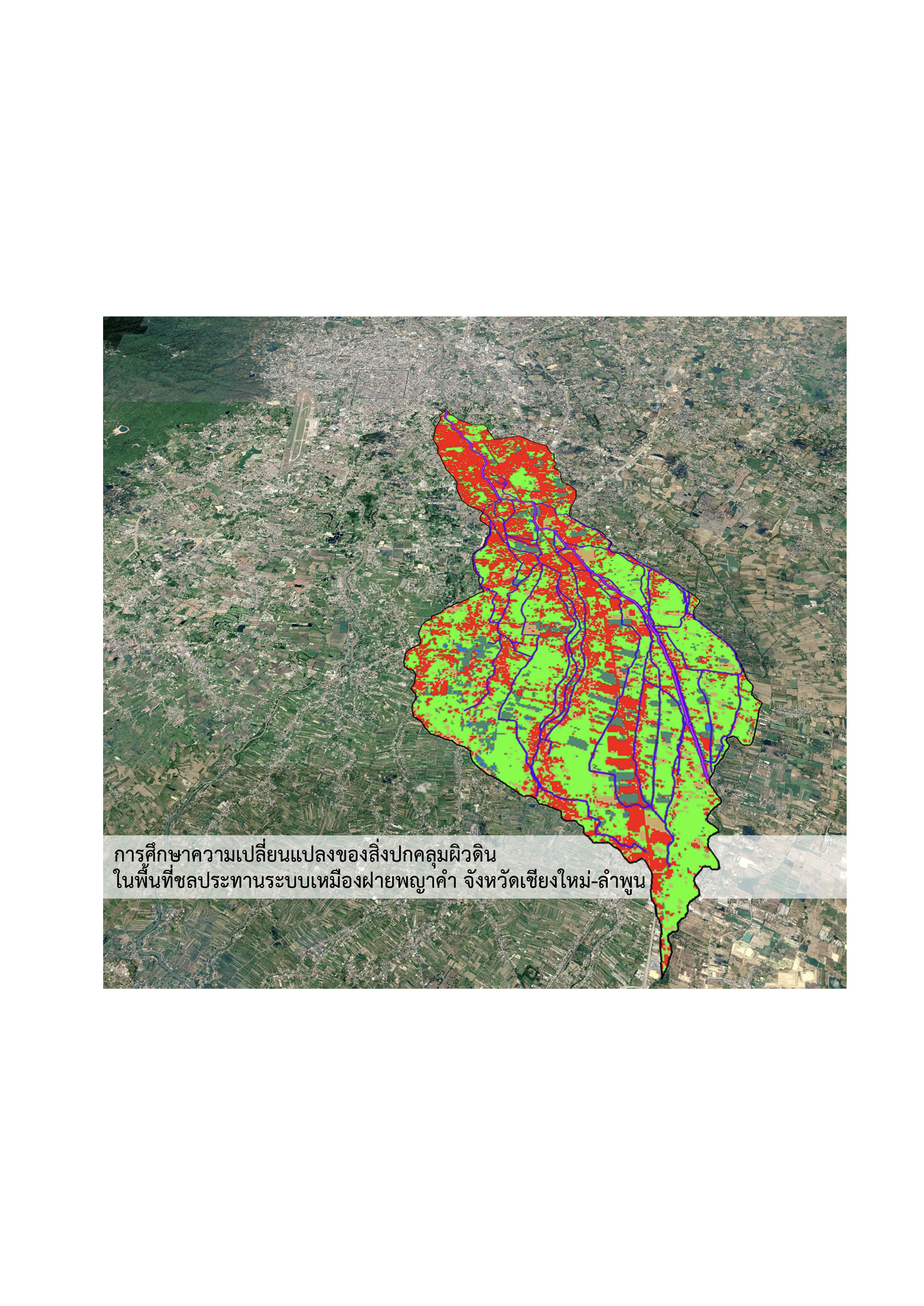
การศึกษานี้มีวัตถุประสงค์เพื่อวิเคราะห์การเปลี่ยนแปลงของสิ่งปกคลุมผิวดินและผลกระทบเชิงนิเวศในพื้นที่ชลประทานระบบเหมืองฝายพญาคำ จังหวัดเชียงใหม่และลำพูน ตลอดช่วงระยะเวลา 30 ปี ระหว่าง พ.ศ. 2539–2569 โดยประยุกต์ใช้ระบบสารสนเทศภูมิศาสตร์ (GIS) ร่วมกับข้อมูลภาพถ่ายดาวเทียม Landsat 5 และ Landsat 9 เพื่อจำแนกสิ่งปกคลุมผิวดินด้วยวิธีการจำแนกแบบกำกับดูแลโดยใช้ตัวจำแนกความน่าจะเป็นสูงสุด (Maximum Likelihood Classifier หรือ MLC) ออกเป็น 5 ประเภท ได้แก่ พื้นที่เมืองและสิ่งปลูกสร้าง แหล่งน้ำ พื้นที่ชุ่มน้ำ พื้นที่โล่ง และพื้นที่เกษตรกรรม
ผลการศึกษาพบว่าการจำแนกข้อมูลมีความถูกต้องในระดับสูง โดยปี พ.ศ. 2539 มีค่าความถูกต้องโดยรวมร้อยละ 91.30 และค่าสัมประสิทธิ์แคปปาเท่ากับ 0.83 ขณะที่ปี พ.ศ. 2569 มีค่าความถูกต้องโดยรวมร้อยละ 87.09 และค่าสัมประสิทธิ์แคปปาเท่ากับ 0.82 การเปลี่ยนแปลงที่สำคัญที่สุดคือการเพิ่มขึ้นของพื้นที่เมืองและสิ่งปลูกสร้างร้อยละ 514.6 จาก 2,190.10 ไร่ เป็น 13,461.06 ไร่ ขณะที่พื้นที่ชุ่มน้ำลดลงอย่างมีนัยสำคัญร้อยละ 79.6 จาก 14,856.96 ไร่ เหลือ 3,033.68 ไร่ ส่วนพื้นที่เกษตรกรรมมีการเปลี่ยนแปลงสุทธิลดลงเพียงร้อยละ 0.34 แต่พบการเปลี่ยนผ่านภายในพื้นที่อย่างต่อเนื่อง โดยเฉพาะการถูกแทนที่ด้วยพื้นที่เมืองและการขยายตัวเข้าสู่พื้นที่ชุ่มน้ำเดิม
ผลการศึกษาสะท้อนให้เห็นถึงพลวัตของการเปลี่ยนแปลงภูมิทัศน์จากระบบเกษตรกรรมชลประทานแบบดั้งเดิมไปสู่ภูมิทัศน์เมือง ซึ่งส่งผลต่อการสูญเสียพื้นที่รับน้ำและลดทอนนิเวศบริการที่สนับ
สนุนการจัดการน้ำของระบบเหมืองฝาย ดังนั้น ระบบเหมืองฝายจึงควรถูกพิจารณาใหม่ในฐานะโครงสร้างพื้นฐานสีน้ำเงิน–เขียว (Blue-Green Infrastructure) ที่มีบทบาทในการบรรเทาอุทกภัย อนุรักษ์ความหลากหลายทางชีวภาพ และเสริมสร้างความยืดหยุ่นของเมือง (Urban Resilience) เพื่อสนับสนุนการวางแผนและการจัดการเมืองอย่างยั่งยืนภายใต้บริบทของการเปลี่ยนแปลงสภาพภูมิอากาศ
ผลการศึกษาพบว่าพื้นที่ชุ่มน้ำลดลงอย่างมีนัยสำคัญ โดยมีการเปลี่ยนไปเป็นพื้นที่เกษตรกรรมจำนวน 8,399.51 ไร่ และเปลี่ยนไปเป็นพื้นที่เมืองและสิ่งปลูกสร้าง 3,928.13 ไร่ ขณะเดียวกัน พื้นที่เกษตรกรรมกว่า 6,506.90 ไร่ได้เปลี่ยนไปเป็นพื้นที่เมือง แม้ว่าพื้นที่เกษตรกรรมสุทธิในภาพรวมจะลดลงไม่มาก แต่พบว่ามีเพียงร้อยละ 39 ของพื้นที่เกษตรกรรมเดิมที่คงอยู่ตลอดช่วงเวลา 30 ปี สะท้อนการหมุนเวียนและแทนที่ของพื้นที่ในระดับโครงสร้างภูมิทัศน์สูงกว่าร้อยละ 60
การเปลี่ยนแปลงดังกล่าวชี้ให้เห็นถึงการเปลี่ยนผ่านจากภูมิทัศน์ที่มีศักยภาพในการซึมน้ำและหน่วงน้ำ ไปสู่ภูมิทัศน์ที่มีพื้นผิวทึบน้ำเพิ่มขึ้นอย่างต่อเนื่อง ซึ่งมีนัยสำคัญต่อความสามารถในการจัดการน้ำ ความยืดหยุ่นเชิงนิเวศ และบทบาทของระบบเหมืองฝายในฐานะโครงสร้างพื้นฐานสีน้ำเงิน–เขียวของเมือง ผลการศึกษาจึงเสนอให้การจัดการพื้นที่ลุ่มน้ำเมืองควรพิจารณามิติทางนิเวศและภูมิทัศน์ควบคู่กับมาตรการทางวิศวกรรม เพื่อเสริมสร้างความยั่งยืนในระยะยาว
Article Details

อนุญาตภายใต้เงื่อนไข Creative Commons Attribution-NonCommercial-NoDerivatives 4.0 International License.
เอกสารอ้างอิง
Anderson, J. R., Hardy, E. E., Roach, J. T., & Witmer, R. E. (1976). A land use and land cover classification system for use with remote sensor data [Government report]. U.S. Geological Survey. https://doi.org/10.3133/pp964
Campbell, J. B., & Wynne, R. H. (2011). Introduction to remote sensing (5th ed.). Guilford Publications. https://books.google.co.th/books?id=NkLmDjSS8TsC
Chummathaya, A., & Ongsawangchai, N. (2018). Urbanization and urban context variants of old districts in Chiang Mai. JEDI : Journal of Environmental Design Innovation, 5(1), 60–81. https://so02.tci-thaijo.org/index.php/jed/article/view/136827
Congalton, R. G., & Green, K. (2019). Assessing the accuracy of remotely sensed data: Principles and practices (3rd ed.). CRC Press.
Folke, C. (2006). Resilience: The emergence of a perspective for social–ecological systems analyses. Global Environmental Change, 16(3), 253–267. https://doi.org/10.1016/j.gloenvcha.2006.04.002
Geo-Informatics Center for Thailand (GISTHAI). (1999). Geographic information system. http://www.gisthai.org/v2/index.php/resources/education/menu-learning-gis
GIS Geography. (2021). Vector vs raster: What’s the difference between GIS spatial data types?. https://gisgeography.com/spatial-data-types-vector-raster/
Google Earth. (2021). Aerial photograph of Chiang Mai-Lamphoon Basin [Aerial imagery]. Google. https://earth.google.com
Gu, Z., Phakdimek, S., Nagami, K., & Komori, D. (2025). Relationship between urbanization–induced land use changes and flood risk: Case study in Chiang Mai, Thailand. Water, 17(3). https://doi.org/10.3390/w17030327
Hersperger, A. M., Grădinaru, S. R., Pierri Daunt, A. B., Imhof, C. S., & Fan, P. (2021). Landscape ecological concepts in planning: Review of recent developments. Landscape Ecology, 36(8), 2329–2345. https://doi.org/10.1007/s10980-021-01193-y
Humboldt State University. (2017). Raster to vector: Conversion between data models. http://gsp.humboldt.edu/olm_2017/Lessons/GIS/08%20Rasters/RasterToVector.html
Jensen, J. R. (2015). Introductory digital image processing: A remote sensing perspective. Pearson Education. https://books.google.co.th/books?id=BWx3CgAAQBAJ
Land Development Department. (2022). Manual for establishing targets and indicators for Land Degradation Neutrality (LDN) to determine land degradation management measures at the local level. https://www.ldd.go.th/web_unccd/File_PDF/ Manual_LDN2565.pdf
Landis, J. R., & Koch, G. G. (1977). The measurement of observer agreement for categorical data. Biometrics, 33(1), 159–174. https://doi.org/10.2307/2529310
Lek-Prapai Viriyahpant Foundation. (2016, January 31). Phaya Kham weir and canal. https://lek-prapai.org/home/view.php?id=428
Lertvicha, P., Methin, S., & Namthep, N. (2009). “Muang Fai” managed water, managed people on the basis of geography and culture. Than Panya.
Lillesand, T. M., Kiefer, R. W., & Chipman, J. W. (2015). Remote sensing and image interpretation (7th ed.). Wiley.
Maneesatit, P. (2016). Changes of Muang Phaya Kham System, Amohie Mueang, Changwat Chiang Mai [Master's thesis, Chulalongkorn University]. Chula ETD. https://digital. car.chula.ac.th/chulaetd/72210
Maneesatit, P. (2023). Study of land cover in “Lanna bioregion”: A case study of Suan Sak campus, Chiang Mai University. JEDI : Journal of Environmental Design Innovation, 10(2), 184–203. https://so02.tci-thaijo.org/index.php/jed/article/view/256211
Maneesatit, P., & Dankittikul, C. (2025). A future approach of Muang Fai irrigation systems in urban area of Chiang Mai province: A systematic review. Journal of Landscape Architecture and Planning, 7(1), 41–62. https://so01.tci-thaijo.org/index.php /LAJ/article/view/280733
Mitrearth [@mitrearth]. (2023, May 19). Chiang Mai Basin topography [Post]. Facebook. https://www.facebook.com/mitrearth/posts/755774196341386/
Mungsunti, A., & Parton, K. A. (2019). The sustainability of the muang fai irrigation system of northern Thailand. AIMS Environmental Science, 6(2), 77–93.
Olofsson, P., Foody, G. M., Herold, M., Stehman, S. V., Woodcock, C. E., & Wulder, M. A. (2014). Good practices for estimating area and assessing accuracy of land change. Remote Sensing of Environment, 148, 42–57. https://doi.org/10.1016/j.rse.2014.02.015
Rakpan, K. (2020). Living museum design for cultural tourism in Inthakhil Village, Inthakhil Subdistrict, Mae Taeng District, Chiang Mai Province. Chiang Mai Rajabhat University Thai Research Database. https://cmudc.library.cmu.ac.th/frontend/Info/ item/dc:183528
Royal Irrigation Department. (2008). Phaya Kham weir irrigation area [Government report]. Royal Irrigation Department.
Sittipong, Y., Shibata, S., & Imanishi, J. (2025). The influence of policies on changing landscape hydro-ecological infrastructure in an urban area: A case study of Chiang Mai City, Thailand. Landscape and Ecological Engineering, 21(4), 895–919. https://doi.org/10.1007/s11355-025-00682-5
Surarerks, W. (1985). Historical development and management of irrigation systems in Northern Thailand. Social Research Institute, Chulalongkorn University.
Tongdeelert, C. (2019, June 26). Muang Fai: A legacy of traditional water management wisdom from northern Thailand. The Citizen Plus Thai PBS. https://drive. google.com/file/d/1xjwiYChLhzGNhtiuyHE8CHlb4-rLFYEo/view?usp =sharing
Tongdeelert, C., & Lohmann, L. (1991). The muang fai irrigation system of northern Thailand. Ecologist, 21, 101–106. https://www.researchgate.net/publication/ 322804696_The_muang_faai_irrigation_system_of_northern_Thailand
United States Geological Survey (USGS). (2026). Satellite imagery of the study area. https://earthexplorer.usgs.gov/
Yodcharoen, S., Harintaka, S., Srisonphan, S., Nualchawee, K., & Silapathong, C. (2017). Land cover classification from satellite images in lam pachi basin by decision tree method. In Thai societies of agricultural engineering (Ed.), Proceeding, The 18th TSAE National Conference and the 10th International Conference : TSAE 2017 (pp. 192–197). Thai societies of agricultural engineering.
