
Analysis of Drainage Capacity and Flood Risk Areas for Integrated Urban Planning of Sam Khok District, Pathumthani Province
Article Sidebar
Main Article Content
Abstract
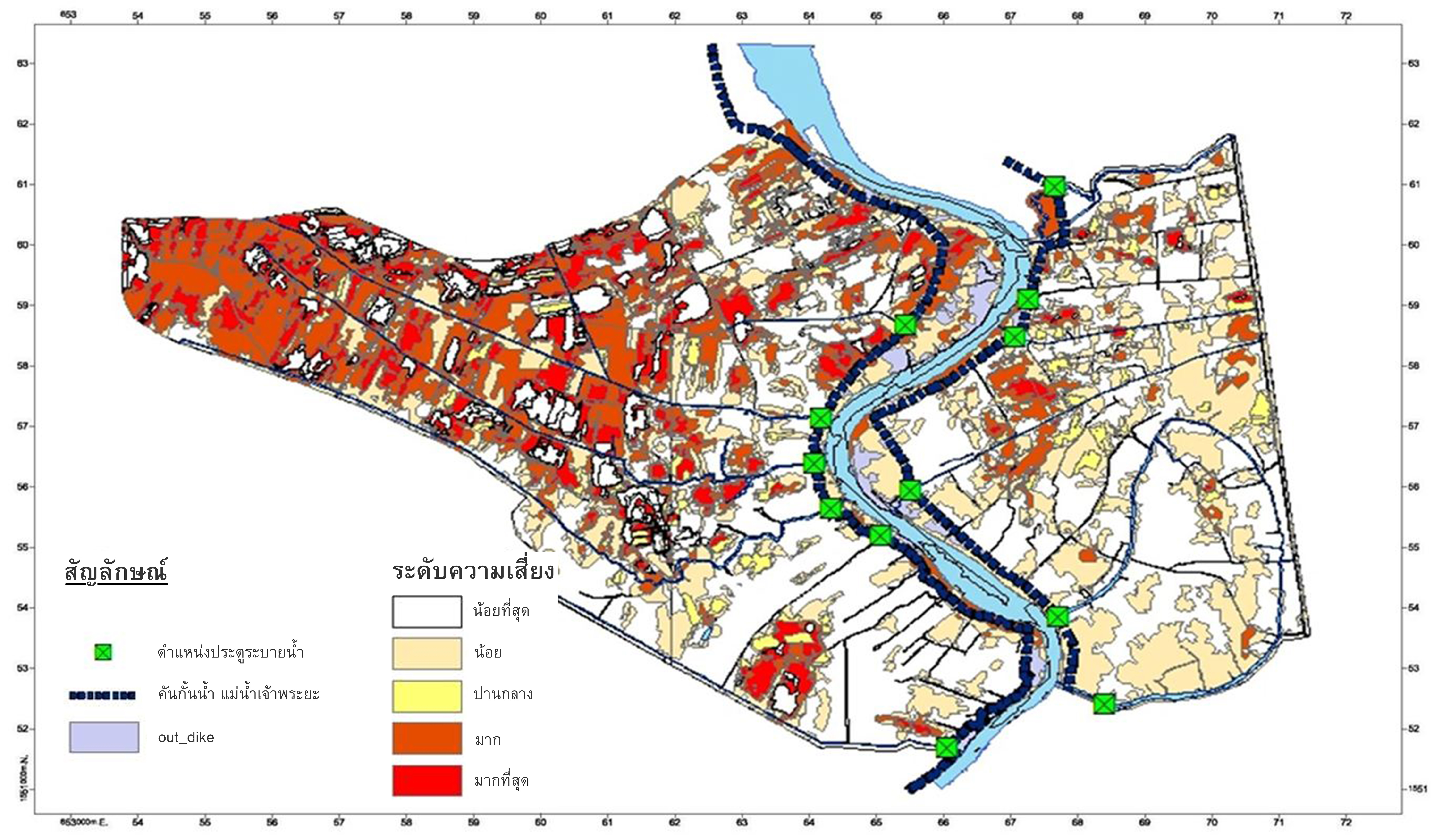
After flood crisis in Thailand in 2011, Department of public works and town planning improved the regulation for urban planning to include flood protection plan in the urban planning. The aim of this paper is to present an analysis of the drainage capacity and flood-risk areas for integrated urban planning of Sam Khok district, Pathum Thani province. The main cause of flooding in this area is overbank from Chao Phraya River. The topography, climate, hydrological and historical flood data of study areas are collected for analysis. Rational method is used to analyze drainage capacity of 12 main canals from total 87 canals by using design rainfall with 5 years return period from Don Muang station. The results show that the drainage capacity of 4 canals (Koi Mai, Bang Pho Neor, Khok Ta Kraw and Khu) are not enough. Flood risk index is calculated to draw flood risk map representing 5 risk levels. The result shows that flood risk in the west of Sam Khok is very high, while flood risk in the southeast of Sam Khok is low. Combined results of flood risk analysis and drainage capacity of main canal are used to define canal plan with 4 sizes: 10, 20, 30 and 40 meter and space area for flood drainage in integrated urban planning of Sam Khok district.
Downloads
Article Details

This work is licensed under a Creative Commons Attribution-NonCommercial-NoDerivatives 4.0 International License.
All material is licensed under the terms of the Creative Commons Attribution 4.0 International (CC-BY-NC-ND 4.0) License, unless otherwise stated. As such, authors are free to share, copy, and redistribute the material in any medium or format. The authors must give appropriate credit, provide a link to the license, and indicate if changes were made. The authors may do so in any reasonable manner, but not in any way that suggests the licensor endorses you or your use. The authors may not use the material for commercial purposes. If the authors remix, transform, or build upon the material, they may not distribute the modified material, unless permission is obtained from JARS. Final, accepted versions of the paper may be posted on third party repositories, provided appropriate acknowledgement to the original source is clearly noted.
References
Bandhitchat, N. (2014). Requirements platform for urban planning. August, 21-22. Bangkok: Department of Public Works and Town & Country Planning.
Chow, V. T., Maidment, D. R. & Mays, L. W. (1988). Applied hydrology. McGraw-Hill: Singapore.
Division of Provincial Affairs. (1993). Water resources database of central region (Volume 2). Bangkok: Department of Provincial Administration.
Faulkner, H., McCarthy, S. & Tunstall, S. (2011). Flood risk communication, In Flood Risk Science and Management (pp. 386-406). UK: Willey-Blackwell.
Kirpich, Z. P. (1940). Time of concentration of small agricultural watersheds. Civil Engineering, 10(6), 362.
Kitparnitchrun, K. & Boonmee, K. (2013). Analysis of extreme rainfall trend of Bangkok. Project of Irrigation Engineering, Department of Irrigation Engineering, Faculty of Engineering, Kasetsart University.
Roachanakanan, T. (2012). Urban disaster resilience. Retrieved from http://www.dpt.go.th/csp/index.php?option=com_content&view=article&id=18&Itemid=71.
Srivanit, M., Hokao, K. & Iamtrakul, P. (2014). Classifying thermal climate zones to support urban environmental planning and management in the Bangkok metropolitan area. Journal of Architectural Research and Studies, 11(1), 73-97.
Urban Space Stonehenge, Joint Venture. (2015). Comprehensive plan of Sam kok. Proceedings of Town and Country Planning Board, Bangkok, Thailand: Department of Public Works and Town & Country Planning.
