
The Efficiency Accessibility of Eco-Friendly Circulation Network by Bicycle Way and Pedestrian Way Approach to Green University Maejo University, Chiang Mai Province
Article Sidebar
Main Article Content
Abstract
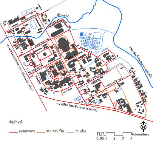
Research is a morphological spatial study. Purpose was to find an accessibility efficiency of circulation network based on green university concept, Space Syntax theory and Geo-Informatics System (GIS) to analyze eco-friendly circulation networks of pedestrian way and bicycle way. It found that circulation networks are linear and curve linear patterns. An Intanin road is the main road that has the highest accessibility efficiency of global integration value ([HH]), local integration value ([HH] R3) and connectivity integration value measured 2.8330, 4.0373 and 28, respectively. The correlation of connectivity and [HH], connectivity and [HH] R3 are quite low. These values show that people have difficulty in understanding and remembering the route of circulation networks. However, the circulation network has the advantage of having very high correlation of [HH] R3 and [HH] measured 0.8716 which mean that people have great alternatives of route choice in circulation network. Otherwise, it found that an accessibility efficiency of circulation network and existing pedestrian routes of user have not related with an existing university pedestrian network. Results from, characteristic of university pedestrian network are fragment and cannot linkage.
Downloads
Article Details

This work is licensed under a Creative Commons Attribution-NonCommercial-NoDerivatives 4.0 International License.
All material is licensed under the terms of the Creative Commons Attribution 4.0 International (CC-BY-NC-ND 4.0) License, unless otherwise stated. As such, authors are free to share, copy, and redistribute the material in any medium or format. The authors must give appropriate credit, provide a link to the license, and indicate if changes were made. The authors may do so in any reasonable manner, but not in any way that suggests the licensor endorses you or your use. The authors may not use the material for commercial purposes. If the authors remix, transform, or build upon the material, they may not distribute the modified material, unless permission is obtained from JARS. Final, accepted versions of the paper may be posted on third party repositories, provided appropriate acknowledgement to the original source is clearly noted.
References
Hillier, B. (1996). Space is the machine. Cambridge: Cambridge University Press.
Jacob, J. (1961). The death and life of great American cities. England: Middlesex.
Khongouan, W. & Sakulrattanakulchai, S. (2014). Guidelines to promote cycling on university campus: case study of Kasetsart University, Mahidol University and Thammasat University. Journal of Architectural/ Planning Research and Studies, 11(1), 37-58.
Maejo Uniersity. (2012). Maejo University road map 2012-2026. Retrieved February 2013, from http://planning2.mju.ac.th/goverment/20111119104835_planning/File20130924155549_15994.pdf
Nateewuttikul, K. (2008). Analytical underground pedestrian ways by space syntax technique for energy saving in central business district area, Bangkok metropolitan. Retrieved March 2013, from http://www.cuurp.org/B_resource/B_data/b1/2551/04.sustrainpowercitypedustrail.pdf
Paksukcharern, K. (2005). Urban discourses through morphological structure. Retrieved March 2013, from http://www.cuurp.org/B_resource/B_data/articles/KP_writing.pdf
Rangsirot, S. et al. (2014). Urban morphological analysis for Chiang Mai walking street space utilization improvement. Retrieved March 2015, from http://archmis.arch.nu.ac.th/arch_ajnu/journal/article_file/article_11.pdf
Santad, C. (2005). The guidelines for public space improvement of Thammasat University, Tha-prachan campus: Spatial and movement network analysis. Journal of Architectural/Planning Research and Studies, 2(3), 185-206.
Santitham, K. (2006). Planning and management toward green and clean university: Thammasat University, Rangsit campus. Journal of Architectural/Planning Research and Studies, 4(2), 155-186.
UI Green Metric. (2011). Guidelines of UI green metric world university Ranking 2011. Retrieved January 2011, from http://greenmetric.ui.ac.id/web/upload/_pdf
UI Green Metric World University Green Ranking. (2013). UI Green Metric World University Green Ranking 2013. Retrieved September 2013, from http://greenmetric.ui.ac.id/ranking/year/2013
