
The Experimental Result of Tactile Map to Guide the Blind at Center of Qualityof Life Improvement for Disabled in The North-eastern Part of Thailand
Article Sidebar
Main Article Content
Abstract
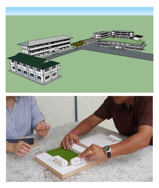
The development of a tactile map to guide the blind at the Center of Quality of Life Improvement for Disabled in The North-eastern Part of Thailand developed and evaluate the use of the tactile map produced from a 3D printer to help guide the blind to access buildings in the Center of Quality of Life Improvement for Disabled in The North-eastern Part of Thailand without a navigation assistant. The qualitative research methods, including observation, questionnaires and interviews were employed. The subjects were 14 blind volunteers, who have been blind since birth and later. They were both those who have been and never lived in Center of Quality of Life Improvement for Disabled in The North-eastern Part of Thailand. The volunteers had to touch the model of the Center, which is big and not portable with the scale of 1: 200, and the portable models with the scales of 1: 400 and 1: 750. The study results revealed that the volunteers were able to understand the layout by touching the models. They could also align the model in the same direction as the context of the Center by using the reference of atmosphere and environment, including the sound of the environment and the temperature of the sunlight as well as experience and Orientation and Mobility (O&M). However, it took time for volunteers who have never lived in the Center to understand and memorize the important positions to be able to guide themselves to various places safely without the need for a navigation assistant, but it took less time for the volunteers who have been in the Center. All subjects were able to perceive the scale and the proportion of the model scaled from the actual size. For the construction of a tactile map, the shape of the building and some areas should be modified to be safe when touching and highlight the essential parts. Braille labels should be used for signs or descriptions. The design and construction of the model of the map for the blind in public areas should be promoted.
Downloads
Article Details

This work is licensed under a Creative Commons Attribution-NonCommercial-NoDerivatives 4.0 International License.
All material is licensed under the terms of the Creative Commons Attribution 4.0 International (CC-BY-NC-ND 4.0) License, unless otherwise stated. As such, authors are free to share, copy, and redistribute the material in any medium or format. The authors must give appropriate credit, provide a link to the license, and indicate if changes were made. The authors may do so in any reasonable manner, but not in any way that suggests the licensor endorses you or your use. The authors may not use the material for commercial purposes. If the authors remix, transform, or build upon the material, they may not distribute the modified material, unless permission is obtained from JARS. Final, accepted versions of the paper may be posted on third party repositories, provided appropriate acknowledgement to the original source is clearly noted.
References
Apelt, R., et al. (2007). Wayfinding design guidelines. Queensland: Cooperative Research Centre of ConstructionInnovation.
Braille Authority of North America. (2017). Size and Spacing of Braille Characters. [Online]. Retrieved January 25, 2017, from http://www.brailleauthority.org/sizespacingofbraille/
Christian Foundation for the Blind in Thailand Under the Royal Patronage of His Majesty the King. (2017, August 12). Center of Quality of Life Improvement for Disabled in the north-eastern part of Thailand. [Online]. Retrieved from http://www.cfbt.or.th/nepd/
Horayangkura, V. (1998). Human Behavior and Environment: Behavioral Basis for Design and Planning (3rd ed.).Bangkok: Chulalongkorn University.
Lowenfeld, B. (1981). Effects of blindness on the cognitive functioning of children. In Berthold Lowenfeld on blindness and blind people: Selected papers. New York: American Federation for the Blind.
Moonwicha, W. (2017). Deputy Director of Christian Foundation for the Blind in Thailand - CFBT. (Personal communication, May 11).
Office of the National Economic and Social Development Board. (2017, November 8). 12th National Economic and Social Development Plan 2017-2021. [Online]. Retrieved from https://www.nesdc.go.th/ewt_dl_link.php?nid=6422
Santiwes, S. (2014). Perception of Space and Surrounding by Color Painting in the Blind. Built Environment Inquiry – BEI Journal, Faculty of Architecture, Khon Kaen University. 13, 41-54.
Yam-iam, C. [trans]. (1988). Community-Based rehabilitation of the rural blind-A training guide for field workers. Bangkok: Donbosgo Press.
Udompiriyasak, S. (2005). Orientation and mobility for the pre-school visually impaired children. Bangkok: Suan Dusit Rajabhat University
