The Role of City Parks: The Case Study of Central Surabaya, East Java, Indonesia
Main Article Content
Abstract
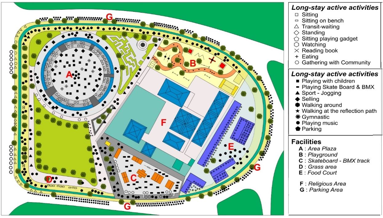
Public space has a certain role in life in urban areas, as a place that is easily accessible, safe, have influence, and benefits of user. This study aims to (1) Determine the quality of city parks in the use of space for their users (2) Identify the role of land use around city parks in the relationship between physical patterns and their activities (3) Identify user behavior patterns. Behavior mapping is a process of observational methods and gear for observation at a location in conditions and times of weekday and weekend. In getting an accurate map of the scale of the observed area, first know and determine the types of activities and details of the behavioral activities to be observed, scheduling within a certain time. And do the system of recording activities, counting, coding the types of activities, taking pictures, and analyzing. The results of this study consists of the role of internal and outside (land use) circulation, and social interaction space. This observation identifies the relationship between land-use with the on-site of park and mapping techniques that produce a pattern of park user activity. The results in counting have a very significant difference between weekday and weekend, results in 3 parks, namely Ekspresi Park weekday (50 visitors), weekend (132 visitors); Lansia Park weekday (50 visitors), weekend (104 visitors); and Bungkul Park weekday (235 visitors), weekend (705 visitors). In conclusion, based on several analyses and observations: Ekspresi Park has a special characteristic that is an educational park with several facilities owned, children dominate the average visitor, Lansia Park has a special characteristic that is an elderly park with several facilities owned, elderly people dominate the average visitor, and Bungkul Park has a special characteristic that is a community park with some complete facilities, visitors dominate the average visitors.
Downloads
Article Details

This work is licensed under a Creative Commons Attribution-NonCommercial-NoDerivatives 4.0 International License.
All material is licensed under the terms of the Creative Commons Attribution 4.0 International (CC-BY-NC-ND 4.0) License, unless otherwise stated. As such, authors are free to share, copy, and redistribute the material in any medium or format. The authors must give appropriate credit, provide a link to the license, and indicate if changes were made. The authors may do so in any reasonable manner, but not in any way that suggests the licensor endorses you or your use. The authors may not use the material for commercial purposes. If the authors remix, transform, or build upon the material, they may not distribute the modified material, unless permission is obtained from JARS. Final, accepted versions of the paper may be posted on third party repositories, provided appropriate acknowledgement to the original source is clearly noted.
References
BARGER, G. (1982). Good Public Space. Retrieved from https://www.cmgsite.com/what-makes-a-good-public-space/
Carr S., Francis, M., Rivlin, L. G., & Stone, A. M. (1992). Public Space. Cambridge [England], NY: Cambridge University Press.
Carmona, M. (2003). Public places - Urban Space. The Dimensions of Urban Design.
Dwi, K., Angga, K. S., Rifan, A. N., & Rachadi, F. (2013). Functions and Activities of Taman Ganesha as a Public Space in the City of Bandung. Journal of Reka Karsa.
Gehl, J. (1936). Cities for people (1st ed.). Washington, DC: Island Press.
Gehl, J,. & Svarre, B. (2013). How to Study Public Life (2nd ed.). Washington, DC: Island Press.
Goličnik, B., & Marušic, D. (2011). Behavioural Maps and GIS in Place Evaluation and Design. 27. doi:10.5772/47940
Hall, E. T. (1966). The Hidden Dimension (31st ed.), 609. NY, USA: Doubleday Anchor Books.
Hariyadi, D. S. (1995). Behaviour mapping. 72-74.
Hesty. (2005). Perfecta green open space system (RTH) to support the creation of comfort and identity of the Metro municipal landscape, Lampung Province, Lampung University.
Ir. Antiek Sugiharti, M. S. (2016). Profil of Surabaya. Profil of Surabaya City. Retrieved from https://surabaya.go.id/uploads/attachments/2016/10/13986/profil_surabaya_2016_vfinal_ar_compressed_compress.pdf
Ittelson, W. H., Rivlin, L. G., & Prohansky, H. M. (1970). The Use of Behavioural Maps in Environmental Psychology, In Environmental Psychology: Man and his Physical Setting. (Holt, Rinehart & Winston, NY.), 668.
Project of Public Space. (2012). What Makes a Successful Place. Retrieved from http://www.PPS.org
Rapoport, A. (1977). Human aspects of urban form : towards a man-environment approach to urban form and design (1st ed.). Oxford, NY: Pergamon Press.
Sunaryo, R. G. (2004). The Position of Public Spaces in Transforming the Conception of Urban Cities in Indonesia.
Wang, D., Li F., & Chai, Y. (2012). Activity spaces and sociospatial segregation in Beijing. Urban Geography,33 (Living in Chinese Enclave Cities), 256-277. doi: 10.2747/0272-3638.33.2.256
Wagner, J. K. (1981). Creating Your City’s Image. National Leaguer of Cities, 23-35.


