
Relationship between Physical Factors and Land Use for the Future Land Use Prediction
Article Sidebar
Main Article Content
Abstract
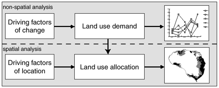
Land use is an indicator of human needs and behaviors that relate to physical, social, political, and technological factors. The objectives of this study 1) to study the relationship between physical factors and land use in B.E. 2562 (A.D. 2019) 2) to forecast the land use change in B.E. 2579 (A.D. 2036). According to relationship between physical factors and land use in B.E. 2562 (A.D. 2019), land use are classified into 13 categories which are integrated farm, paddy field, cassava, para rubber, mixed orchard, vegetables, maize, pasture, aquacultural land, forest area, miscellaneous land, building area, and waterbody in addition, 9 driving factors consist of soil drainage, distance from stream, distance from pond, distance from village, slope, distance from road, distance from fault, annual rainfall, and DEM (digital elevation model) by using logistic regression and correlation. In terms of land use prediction, it is addressed by using the Clumondo model, which requires land use data and factors for future forecasting. And scenario simulations of future events from Markov model. The finding show that the factors have significant influence on the all land use types are DEM, distance from village, distance from pond and distance from road. As results of land use assessment between B.H. 2562 (A.D. 2019) to B.H. 2579 (A.D. 2036), paddy field, para rubber, aquacultural land, forest area, building area, and waterbody were increased while integrated farm, cassava, mixed orchard, vegetables, maize, pasture, miscellaneous land, were decreased. In order to use as a database for future land management planning of the Upper Ing River Basin, Phayao Province
Downloads
Article Details

This work is licensed under a Creative Commons Attribution-NonCommercial-NoDerivatives 4.0 International License.
All material is licensed under the terms of the Creative Commons Attribution 4.0 International (CC-BY-NC-ND 4.0) License, unless otherwise stated. As such, authors are free to share, copy, and redistribute the material in any medium or format. The authors must give appropriate credit, provide a link to the license, and indicate if changes were made. The authors may do so in any reasonable manner, but not in any way that suggests the licensor endorses you or your use. The authors may not use the material for commercial purposes. If the authors remix, transform, or build upon the material, they may not distribute the modified material, unless permission is obtained from JARS. Final, accepted versions of the paper may be posted on third party repositories, provided appropriate acknowledgement to the original source is clearly noted.
References
Amir, A., & Mohammad H. G. (2019). Prediction of spatial land use changes based on LCM in a GIS environment for Desert Wetlands – A case study: Meighan Wetland, Iran. international soil and water conservation research 7, 64-70.
Department of Provincial Administration. (2019). Official Statistics Registration Systems. Retrieved June 04, 2019 from http://stat.dopa.go.th/stat/statnew/upstat_age.php/
Faksomboon, B., & Buasruang S. (2019). Study of Infiltration Rate, Soil Moisture Content and Land use Prediction in Khlong Lan Watershed, Kamphaeng Phet Province. Kamphang Phet Rajabhat University.
Hamad, R., Balzter, H., & Kolo, K. (2018). Predicting Land Use Land Cover Changes Using a CA-Markov Model under Two Different Scenarios. Sustainability. 10, 3421. doi:10.3390/su10103421
Kiriwongwattana, K. (2007). Application of Clue-S Model for Land Use and Land Cover Changes Projection at Mae Yod Watershed, Maechaem District, Chiang Mai Province. Kasetsart University.
Khotapun, C. (2012). application of clue-s model for predicting land use changes in si sa ket province between A.D. 2010 – 2017. Kasetsart University.
Iamtrakul, P., & Klaylee, J. (2018) The Study on Relationship between Social Capital and Site Potential: Case study of Thakhlong Municipality, Pathumthani. Journal of Architectural/Planning Research and Studies. 15(2), 17-41.
Lanchanon, P. (2013). The Potential of Agricultural Lands for Conservation of Green Area in Chiang Mai City. Journal of Architectural/Planning Research and Studies. 10(2), 115-137.
Land Development Department. (2009). Land Use Classification System. Bangkok: Analysis of Land Use Conditions, Land Surveying and Planning Office. Bangkok: Land Development Department.
Limgomonvilas, T. (2014). Prediction of Lamtakong Watershed Land Use in 2024 with CA-MARKOV Model. Journal of Social Sciences Srinakharinwirot University. 17, 94-113.
Losiri, C. (2016). Land Use Change Model and Urban Area Prediction in the Future. Journal of Social Sciences Srinakharinwirot University, 19, 340-357.
Muhammad, H. S., & Han, S. L. (2019). Prediction of Land Use and Land Cover Changes for North Sumatra, Indonesia, Using an Artificial-Neural-Network-Based Cellular Automaton. Sustainability 2019, 11,3024
Ninjun, W. (2017). Comparison of land use and land cover prediction using ca-markov model and land change modeler model a case study of uttaradit provinck. University of Phayao.
Nuchpho, P., & Suwankesorn, S. (2017). Logistic Regression Analysis of Curriculum Quality Factors that Affecting the Employment Situation: A Cases Study of the Bachelor of Business Computer Program, Pibulsongkram Rajabhat University. Parichart Journal Thaksin University. 30(3), 74-85.
Ongsomwang, S., & Iamchuen, N. (2014). Land use prediction using CLUE-S model a case study of Phayao lake, Phayao province. Journal of Remote Sensing and GIS Association of Thailand. 15(1), 26-31.
Ongsomwang, S., Pattanakiat, S., & Srisuwan, A. (2019). Impact of Land Use and Land Cover Change on Ecosystem Service Values: A Case Study of Khon Kaen City, Thailand. Environment and Natural Resources Journal, 17(4), 43-58.
Ornetsmüller, C., Verburg, P., & Heinimann, A. (2016). Scenarios of land system change in the Lao PDR: Transitions in response to alternative demands on goods and services provided by the land. Applied Geography, 75, 1-11.
Pumchan, S., Trisuratand, Y., & Pipatwattanakul, D. (2014). Application of clue – s model and globio 3 model in the assess of land use change on biodiversity. Kasetsart University.
Sourachai, T., & Lileekpal, P. (2011). The Influence ofthe Improvement of Coursecontents In Arc131 Architectural Drawing on Learning Outcome of Arc141 Materials and Construction. Faculty of Architecture, Sripatum University.
Thoeisiri, C. (2017). The extension of urbanized area and its effects on vulnerable area in surat thani province. Thammasat University.
Van, A. S., & Verburg, P. H. (2013). Land cover change or land-use intensification simulating land system change with a global-scale land change model. Global Change Biology, 19 (12). Retrieved from https://doi.org/10.1111/gcb.12331
Van, V. J., & Malek, Z. (2015). The Clumondo land use change model manual and exercises. University Amsterdam.
Vanno, S. (2012). Bangkok’s Green Infrastructure. Journal of Architectural/Planning Research and Studies, 9(2), 1-13.
Verburg, P. H. (2009). Combining top-down and bottom-up dynamics in land use modeling: exploring the future of abandoned farmlands in Europe with the Dyna-CLUE model. Springer Netherlands.
