A Classification of Thai Urban Public Spaces: A Case Study of Bangkok Metropolitan Area, Thailand
Main Article Content
Abstract
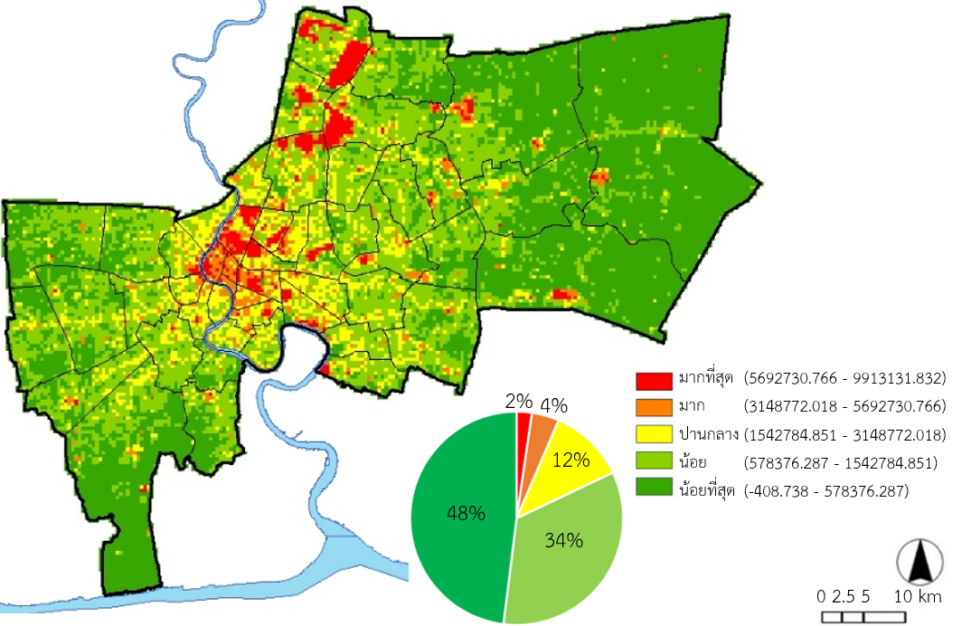
Public spaces are one of the most important social components of the city which have been used to support human activities from the past to the present. At the same time, public spaces can help to reflect the physical characteristics of its surrounding that can identify the unique neighborhoods of each area. Nonetheless, it is not clearly shown in the Thai context. This research aimed to classify urban public space in Thai context by using Bangkok as a study area. The study method is an applying Geographic Information System (GIS) technique for analysis four main factors including urbanity, creativity, identity and sustainability. The results revealed that Thai urban public spaces can be classified into five types according to different contexts influencing roles and pattern of space utilization including; 1) Urban public space located in the city center with main characteristics of access and convenience that can serve various activities and user groups; 2) Community public space representing community location features originated by clustering sub-components of Thai society such as residence, institution and religious place; 3) Public space in the old town district positioned in the traditional district as the first community settlement area or city center in the past; 4) Open public space considered as urban infrastructure with characteristic of large-scale open area spreading across the community; 5) Public space in the sub-center located outside the city with outstanding characteristics of providing convenient lifestyles for residents in the surrounding areas.
Downloads
Article Details

This work is licensed under a Creative Commons Attribution-NonCommercial-NoDerivatives 4.0 International License.
All material is licensed under the terms of the Creative Commons Attribution 4.0 International (CC-BY-NC-ND 4.0) License, unless otherwise stated. As such, authors are free to share, copy, and redistribute the material in any medium or format. The authors must give appropriate credit, provide a link to the license, and indicate if changes were made. The authors may do so in any reasonable manner, but not in any way that suggests the licensor endorses you or your use. The authors may not use the material for commercial purposes. If the authors remix, transform, or build upon the material, they may not distribute the modified material, unless permission is obtained from JARS. Final, accepted versions of the paper may be posted on third party repositories, provided appropriate acknowledgement to the original source is clearly noted.
References
BMA. (2013). Plan Develop Bangkok 20-year (2013 - 2032) Executive Summary (THAI). Retrieved January 15, 2019 from http://readgur.com/doc/2044958
Benn, S. I. & Gaus, G. F. (1983). Public and Private in Social Life. London: Croom Helm.
CABE (2005). The Value of Public Space: How high quality parks and public spaces create economic, social and environmental value. London: CABE.
Carmona, M., Tiesdell, S., Heath, T. & Oc, T. (2010). Public Place Urban Space. Oxford: Architectural Press.
Carr, S. (1992). Public space. New York: Cambridge University Press.
Chrysoulakis, N., Feigenwinter, C., Triantakonstantis, D., Penyevskiy, I., Tal, A., Parlow, E., Fleishman, G., Duzgun, S., Esch, T. & Marconcini, M. (2014). A Conceptual List of Indicators for Urban Planning and Management Based on Earth Observation. ISPRS International Journal of Geo-Information, 3(2014), 908-1002.
Department of City Planning and Urban Development, BMA (2018). The Bangkok Comprehensive Plan 2013 (B.E.2556). Retrieved March 5, 2019 from http://cpd.bangkok.go.th:90/web2/kitja56/kitja56
Department of Environment, BMA (2018). Report of the main parks in Bangkok. Retrieved April 19, 2019 from http://203.155.220.118/green-parks-admin/
Dorothy C. Ibes. (2015). A multi-dimension classification and equity of an urban park system: A novel methodology and case study application. Perspectives from multi-source geographic data. Landscape ans Urban Planning, 137(2015), 122 – 137.
Gehl, J. (2001). Life between Buildings. Using Public Spaces (4th Edition). Copenhagen: The Danish Architectural Press.
Guo, S., Yang, G., Pei, T., Ma, T., Song, C., Shu, H., Du, Y., & Zhou, C. (2019). Analysis of factors affecting urban park service area in Beijing: Perspectives from multi-source geographic data. Landscape ans Urban Planning, 181(2019), 103 – 117.
Ibes, D. C., (2015). A multi – dimensional classification and equity analysis of an urban park system: A novel methodology and case study application. Landscape and Urban Planning, 137(2015), 122-137.
Jacobs, J. (1961). The Death and Life of Great American Cities. Retrieved 24 March 2018, from https://www.buurtwijs.nl/sites/default/files/buurtwijs/bestanden/jane_jacobs_the_death_and_life_of_great_american.pdf
Kaplan, S. & Kaplan, R. (1982). Cognition and Environment: Functioning in an Uncertain World (6 th edition). New York: Preager.
Kongphunphin, C., Iamtrakul, P. & Srivanit, M. (2018). The attitude in Urban Planning of Thai Urban Public Space. International Journal of Building, Urban, Interior and Landscape Technology. 12(2018), 59-73.
Lynch, K. (1960). The Image of the City. London: The MIT Press.
Madanipour, A. (2010). WHOSE PUBLIC SPACE?. New York: Routledge.
Marcus, C., & Francis, C. (1998). PEOPLE PLACES Design Guidelines for Urban Open Space. New York, Van Nostrand Reinhold.
Nathiwutthikul, K. (2014). The Development and Types of Public Open Space. In Suwatcharapinun, S. (Ed.), Towards Architectural Theories: Public Social Space, 4 - 26. Chiang Mai: Chiang Mai University Press.
Project for Public Spaces. (2008). WHAT MAKES A SUCCESSFUL PLACE? Retrieved May 29, 2019 from https://www.pps.org/article/grplacefeat
Roszkowska, E. (2013). Rank ordering criteria weighting methods-a comparative overview: optimum. Studia Ekonomiczne, NR 5(56), 14-33.
Srivanit, M., & Auttarat, S. (2016). Classifying Spatial Homogeneity of Thermally-Stabilized Surface to Define Differentiation Local Atmospheric Zones in Chiang Mai City. Journal of Architectural/Planning Research and Studies. 13(2016), 1-21.
Summaniti, L. (2002). Theory of Urban and Regional Planning. Retrieved April 16, 2019 from http://coursewares.mju.ac.th:81/e-learning50/la471/course_chapt_menu.html
UN-Habitat (2015). Transforming our world: the 2030 Agenda for Sustainable Development. Retrieved August 26, 2018 from http://www.un.org/ga/search/view_doc.asp?symbol=A/RES/70/1&Lang=E
WHO. (2015). Health Indicators of sustainable cities in the Context of the Rio+20 UN Conference on Sustainable Development. Retrieved November 14, 2018 from http://origin.who.int/hia/green_economy/indicators_cities.pdf.122.
Ye, Y. & Nes, A. (2014). Qualitative tools in urban morphology: conbining space syntax, spacematrix and mixed-use index in a GIS framework. Urban Morphology, 18(2), 97-118.


