
Flood and Drought Risk Indicators for Small Watershed
Article Sidebar
Main Article Content
Abstract
Chiangmai basin is surrounded by several of small low hill watersheds which encountered with the explanation of problem situations under the influence of urban expansion. Moreover, flood and drought circumstances become chronic problems having an effect on watersheds until it is difficult to solve the problem. This study focused on develop index and risks determination on flood and drought of small watershed to generate an evaluation model of low hill watershed near several cities of upper northern plain. which participatory action research was employed with the target population groups. The study began with the application of geo-information database for explanation of drought and flood risk level including area impacts leach watershed. Then, empirical evidence were found to explain results which connected with academic reasons. Meanwhile, main factors were estimated and screened target indicators on watershed management area found.
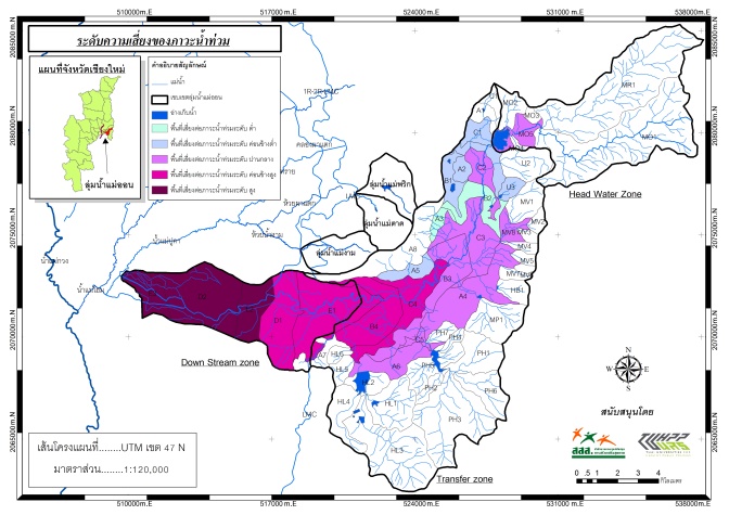
The index were presented as follows: 1) Flood assessment – Four indices were used to investigate the flood which consisted of Rainfall index, runoff quantity index, drainage capability index and land use index, and 2) Drought assessment – Four indices were applied to examine the drought which comprised of Rainfall index, water yield capability, potential to access water resource of agricultural area and water demand for agricultural area. The results of study found several interesting issues as follows. The middle zone was assessed as drought area due to dry spell, delayed raining condition in 2012–2015 combined with the morphological characteristics of its upland agricultural area and intensive agriculture particularly off-season rice planting and the shallow condition of natural water reservoirs and existing reservoirs kept less amount of water. These resulted to the severity level of drought more increasingly and the risk would be extended more broadly. The lower areas was assessed as severe flooding problem because it was the area receiving the water from the Mae On upper zone and some areas were still the conjunction point of the main river which appeared narrow and shallow conditions because of many changes like the outer ring road resulted to obstruction of the water drainage. At the same time, many areas receiving the flood water were filled with the ground for housing projects and new commercial areas including some parts along the riverside were changed to be the housing areas.
Based on results of the study, the following were found as follow 1) using database to screen target indicators which indicated problem situations and focused management through the combination of technology, for example geographic information system, with the management by local knowledge as a tool in the study process. This was done together with situation learning and analysis under updated database. After that, obtained results were used for watershed management planning. Evidence-based was an important key leaching the preparation of an area action plan with the local administrative organization for determination of local legislation on water management and its related issues.
Downloads
Article Details

This work is licensed under a Creative Commons Attribution-NonCommercial-NoDerivatives 4.0 International License.
All material is licensed under the terms of the Creative Commons Attribution 4.0 International (CC-BY-NC-ND 4.0) License, unless otherwise stated. As such, authors are free to share, copy, and redistribute the material in any medium or format. The authors must give appropriate credit, provide a link to the license, and indicate if changes were made. The authors may do so in any reasonable manner, but not in any way that suggests the licensor endorses you or your use. The authors may not use the material for commercial purposes. If the authors remix, transform, or build upon the material, they may not distribute the modified material, unless permission is obtained from JARS. Final, accepted versions of the paper may be posted on third party repositories, provided appropriate acknowledgement to the original source is clearly noted.
References
Achutun, V. R., Steyaert, L. T., & Sakamoto, C. M. (1982). Agroclimatic assessment methods for drought/flood shortages in South and Southeast Asis-test and evaluation. Columbia: Missouri University.
Amornwat, C. (2015). The tangible sign of reconsidering the second Chiangmai Airport on wild spread landuse change of ownership by real estate sector. Retrieved November 20, 2017 from https://www.prachachat.net.
Community Organization and Northern River Basin Organizations. (2012).Recommendation guideline for water resources and disaster by Northern people network In Proc. of the recommendation guideline for water resources and disaster by Northern people network conference. 22-23 March, 2013 at the Lumphun Phukham Hall, Lumphun, Thailand. Retrieved November 14, 2017 from http://www.codi.or.th/webcodi/sapa/index.php?option=com2.
Daungthima, W., & Hokao K. (2015). Development of Support System Tools for Protect Cultural Heritage Sites from Flood Risk (PCH) Plug-in Tools. Journal of Architectural/Planning Research and Studies, 12(1), 123-134.
Dhanarun, S., & Amonsanguansin, J. (2010). Application of geographic information system for flood risk area assessment in Angthong province. Journal of environmental management, 6(2), 19-34.
DHI Water Environment and Health. (2007). MIKE11-A modelling system for rivers and channels (Reference Manual). Denmark: Author.
Forestry Research Center. (1994). Research report on risk area assessment of flood and drought in North East watershed. Bangkok: Kasetsart University.
Gibbs, W. J., & Maher, J. V. (1967). Rainfall deciles as drought indicators. Melbourne: Bureau of Meteorology.
Hirunchet, N. (2016). Chaingmai nerver stop growing. Retrieved November 20, 2017 from https://www.prachachat.net.
Mckee, T. B., Doesken, N. J., & Kleist, J. (1993). The relationship of drought frequency and duration times scales. In American meteorological society. 8th conference on applied climatology, (pp. 17-22). Janvier, Anaheim: CA.
Mingtipol, O., Kowsuwan, N., Powjinda, Y., & Srisuk, Y. (2015). Mae On integrated watershed management for downstream flooding mitigation (Final report). Bangkok: Thai Health Promotion Foundation.
Naga, S. (2015). Analysis of flood risk areas in the upper Pasak river basin, Lomsak, Phetchabun. Master of Geographic Information Science Thesis. Phitsanulok, Thailand: Department of Natural Resources and Environment, Naresuan University.
Office of Natural Resources and Environmental Policy and Planning. (2012). Thailand’s nature and environment journal. Retrieved April 24, 2016 from http://www.onep.go.th/index.php?option=com.
Office of Natural Calamity and Agricultural Risk Prevention. (2012). Repetitive risks areas. Bangkok: Land Development Department. Retrieved June 23, 2013 from http://os1101.ldd.go.th.
Office of Agricultural Economics. (2015). Drought impact. Retrieved May 20, 2015 from http://www.oae.go.th.
Palmer, W. C. (1965). Meteorological drought (U.S. Research Paper No. 45.). Washington, D.C.: U.S. Department of Commerce Weather Bureau.
Taesombat, W. (2011). An application of MIKE11-Data assimilation model for flood forecasting in the upper Chi River basin. The 11st national convention on civil engineering. Bangkok: Mahidol University.
Watcharakorn, C. (2007). Impact of land use on flooding: A case study of lower Mae Orn watershed, Sankamphaeng district, Chiang Mai province. Master of Science in sustainable land use and natural resource management Thesis. Chiangmai, Thailand: Mae Jo University.
Wangwongwiroj, N. (2008). Hydrology. Bangkok, Thailand: Darnsutha press.
Yao, A. Y. M. (1969). The R index for plant water requirements. Agricultural Meteorology, 6(4), 259-273.
