
Spatial Transformation and Accessibility Efficiency of Transportation Network with Land Use in the Context of Chiang Mai Comprehensive Plan
Article Sidebar
Main Article Content
Abstract
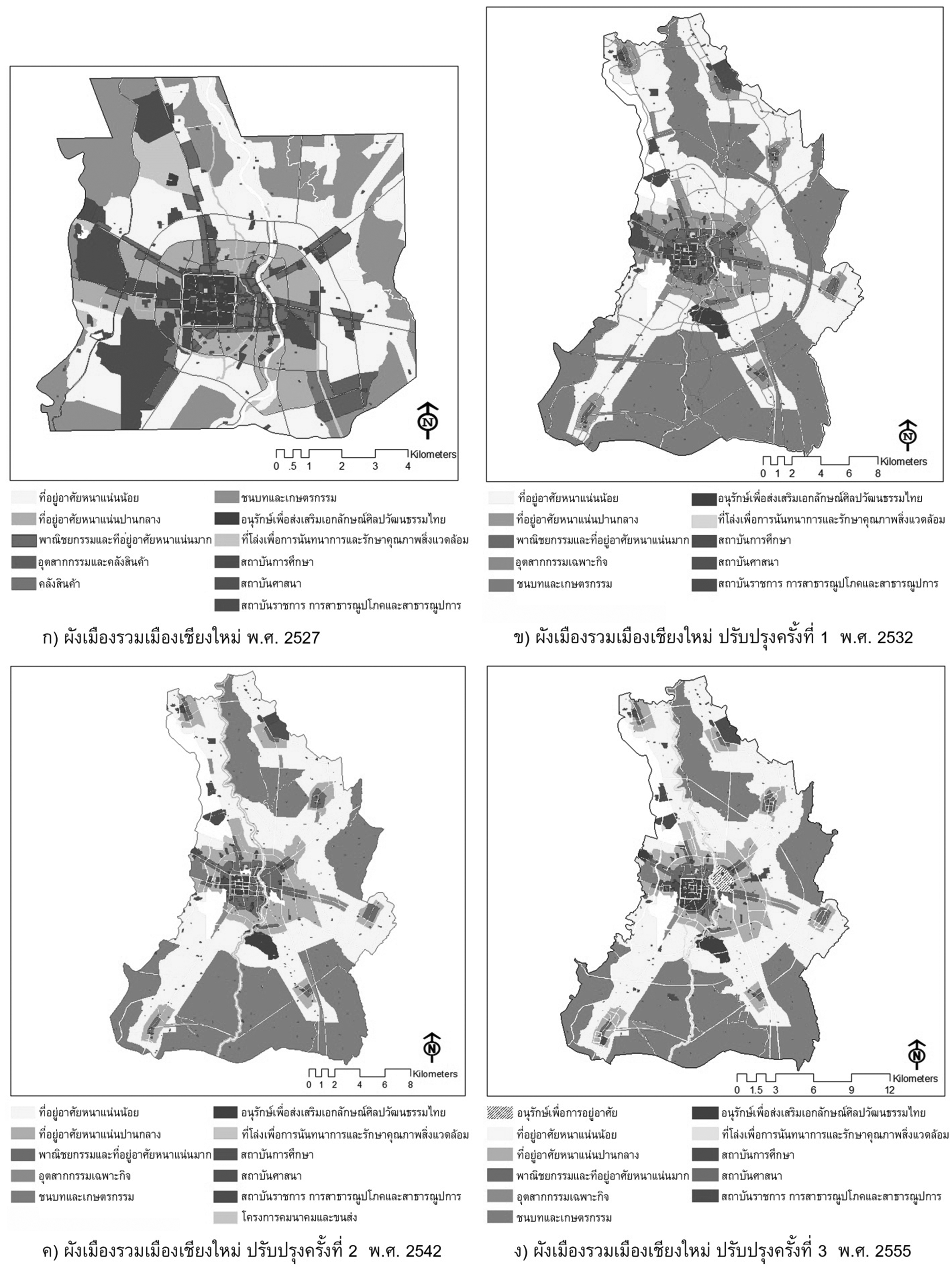
This spatial research aimed to analysis the accessibility efficiency of transport network plan and land use plan in the context of Chiang Mai comprehensive plan since 1984 which the first modification in 1989, the second modification in 1999 and the latest modification in 2012. The study was undertaken by documentary analysis, surveying, Geo Informatics System analysis, an analysis of land use plan and transportation network plan of Chiang Mai comprehensive plan including theory and Space Syntax technique. They were all used to analyze the morphological spatial structure of transportation network plan. It was found that the area of Chiang Mai comprehensive plan was increased from 106.0 square kilometers in 1984 to 429.0 square kilometers in 1984 and at the present time. On average, the accessibility efficiency indexes of changes of the morphological structure of the transportation network plan measured by the Space Syntax Model were 0.279821, 0.205415, 0.203256 and 0.214098, respectively. The characteristics of the transportation network were in the forms of a ring-road and a radial ring-road linking from the city center. Both were in conjunction with the schemes of land use types in Chiang Mai City Center for commercial purposes and very dense residential areas surrounded by medium and less density residential areas interspersing with rural and agricultural areas. The characteristic of morphological structure of the city center in 1984 was in the center of Chiang Mai city. Later, in the year 1989, it was extended to the South. From the year 1999 up until the present time, it had been extended to the East along the National Highway No. 1. Moreover, the accessibility efficiency index at the junction of the ring-road and the radial ring-road was higher than those of other areas. This brought about the blooming of suburb centers since 1999 which had a tendency to cause changes to land use of the mentioned suburban, rural and agricultural areas. Finally, a main factor of the spatial changes was the result of accessibility efficiency to the aforementioned transportation network. Therefore, in the future, measures to control the land utilization in Chiang Mai to reduce the negative impacts on suburban rural and agricultural areas should be considered.
Downloads
Article Details

This work is licensed under a Creative Commons Attribution-NonCommercial-NoDerivatives 4.0 International License.
All material is licensed under the terms of the Creative Commons Attribution 4.0 International (CC-BY-NC-ND 4.0) License, unless otherwise stated. As such, authors are free to share, copy, and redistribute the material in any medium or format. The authors must give appropriate credit, provide a link to the license, and indicate if changes were made. The authors may do so in any reasonable manner, but not in any way that suggests the licensor endorses you or your use. The authors may not use the material for commercial purposes. If the authors remix, transform, or build upon the material, they may not distribute the modified material, unless permission is obtained from JARS. Final, accepted versions of the paper may be posted on third party repositories, provided appropriate acknowledgement to the original source is clearly noted.
References
Auttarat, S. (2014). The expiration of comprehensive plans and their impacts on local development in thenorthern region. Journal of Architectural/Planning Research and Studies, 11(2), 83-97.
Chiang Mai Provincial. (2016). Chiang Mai economic report 2016. Retrieved March 2017, from http://www.cgd.go.th/cs/cmi/.
Department of Public Works and Town and Country Planning. (2016). North Thailand regional plan 2057. Bangkok: Panya Consultants.
Hillier, B. (1996). Space is the machine. Cambridge: Cambridge University Press.
Hillier, B., & Hanson, J. (1984). Social logic of space. Cambridge: Cambridge University Press.
Kaseamsuk, A. (2001). Spatial and differentiation: Symbolic and syntagmatic relationship. Retrieved January 21 2017, from http://www.spacesyntax.net/symposia/ss4/fullpaper/11kasemsookpaper.pdf.
Paksukcharern, K. (2005). Urban discourses through morphological structure. Retrieved March 2017, from http://www.cuurp.org/B_resource/B_data/articalesKP_writing.pdf.
Prachatai. (2005). Local road exist: Safety must come first. Retrieved May 2017, from https://prachatai.com/journal/2005/02/2907.
Srivanit, M., & Auttarat, S. (2016). Classifying spatial homogeneity of thermally-stabilized surface to define differentiation local atmospheric zones in Chiang Mai city. Journal of Architectural/Planning Researchand Studies, 13(1), 1-21.
Subsuk, S. (2002). Transformation of Bangkok settlement: A morphological study of spatial network of Bangkok of 20th century. (A pilot study for Doctoral Dissertation). Graduated of Science and Technology, Kobe University.
Summaniti, L. (2010). Transformation of spatial centrality on the western areas of Chao Phraya Delta: The result of model change from water-based to land-based transportation. Proceeding of The 3rd ATRANS Symposium: Asian Transportation Research Society, Bangkok, Thailand, 46-57.
Summaniti, L. (2013). Morphological urbanization in the context of orchard-based settlement on the western bank of the Chao Phraya river. Proceeding of 1st Landscape and Environmental Conference.Chiang Mai, Thailand, 100-109.
Summaniti, L., Peerapun, W., & Puksukcharean, K. (2012). Suan Nai Bangkok and Suan Nok Bang Chang: The emergence and transformation of floating markets in the Chao Phraya River Delta of Thailand. Nakhara Journal of Environmental Design and Planning. 8(1), 73-83.
The Bureau of Registration Administration, Department of Provincial Administration, (2015). Statistics registration system. Retrieved July 2017, from http://stat.bora.dopa.go.th/stat/statnew/statTDD/.
World Health Organization. (2017). Global observatory on health R&D. Retrieved January 22 2017, from http://www.who.int/research-observatory/en/.
